Lone Peak Wilderness
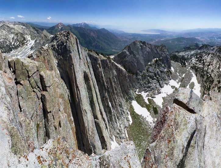
Lone Peak Wilderness is a 30,632-acre wilderness area in Utah County, Utah. It rises from about 5,118 to 11,291 ft. The nearest town is Granite, 0.4 miles away in a straight line.
Lone Peak Wilderness map
Lone Peak Wilderness boundary from USGS PAD-US or the managing agency, simplified for display. Not for navigation or legal boundaries.
Fire restrictions
5 fire restriction orders are recorded for this unit as of Sept. 30, 2026. Each links the signed order.
- Forest Service (USFS) - Manti-La Sal NF, Ferron RD (Black Canyon Rd) (Closure) Effective Sept. 11, 2026. Applies to the part of this wilderness managed by Pleasant Grove Ranger District. Listed as Active on Utah Fire Info. The signed order states the exact area, what it prohibits, and exemptions.
- Forest Service (USFS) - Babylon Fire Closure - Manti-La Sal NF (Monticello RD) Effective July 17, 2026. Applies to the part of this wilderness managed by Pleasant Grove Ranger District. Listed as Active on Utah Fire Info. The signed order states the exact area, what it prohibits, and exemptions.
- Forest Service (USFS) - Cottonwood Fire Closure Effective July 4, 2026. Applies to the part of this wilderness managed by Pleasant Grove Ranger District. Listed as Active on Utah Fire Info. The signed order states the exact area, what it prohibits, and exemptions.
- Forest Service (USFS) - Wild Goose Fire Closure Effective June 27, 2026. Applies to the part of this wilderness managed by Pleasant Grove Ranger District. Listed as Active on Utah Fire Info. The signed order states the exact area, what it prohibits, and exemptions.
- Forest Service (USFS) - Uinta-Wasatch-Cache NF (Ogden RD: Weber Co Wasatch Foothills) (Special Order) Effective June 1, 2026. Applies to the part of this wilderness managed by Pleasant Grove Ranger District. Listed as Active on Utah Fire Info. The signed order states the exact area, what it prohibits, and exemptions.
Utah Fire Info, Utah DNR's interagency fire information hub, keeps the Utah fire restrictions map and signed orders for every fire zone, and a Utah fire map of active fires.
Common questions
- The maximum group size at Lone Peak Wilderness is 15.
- Campfires are prohibited.
- Granite, UT is the nearest town, 0.4 miles in a straight line from the boundary (not a driving distance).
- The highest ground in Lone Peak Wilderness is about 11,291 ft, and its lowest about 5,118 ft (USGS 3DEP elevation model). Its highest named summit is The Pfeifferhorn, about 11,291 ft.
Who manages Lone Peak Wilderness
| Agency | Acres | Permit | Group size | Stay limit | Office |
|---|---|---|---|---|---|
| Forest Service | 30,632 | Not on record | 15 | Not on record | Pleasant Grove Ranger District, 801-785-3563 |
Getting to Lone Peak Wilderness
- Granite, UT is the nearest town, 0.4 miles in a straight line from the boundary (not a driving distance). (US Census places, accessed 2026-09-29)
Trailheads at Lone Peak Wilderness
- Dry Creek Trailhead (alpine) (0.05 mi outside the boundary, 5,648 ft), at 40.4825, -111.7502
- Box Elder Trailhead (0.07 mi outside the boundary, 6,788 ft), at 40.4902, -111.6568
- Temple Quarry Interpretive Trail Trailhe (0.07 mi outside the boundary, 5,388 ft), at 40.5724, -111.7768
- Silver Lake Flat Trailhead (0.09 mi outside the boundary, 7,542 ft), at 40.5068, -111.6564
- Lisa Falls Trailhead (0.1 mi outside the boundary, 6,491 ft), at 40.5723, -111.7267
- Deer Creek Trailhead (0.14 mi outside the boundary, 6,766 ft), at 40.4907, -111.6553
- Park & Ride Little Cottonwood Canyon Tra (0.16 mi outside the boundary, 5,449 ft), at 40.5723, -111.7742
- Grit Mill Trailhead (0.21 mi outside the boundary, 5,613 ft), at 40.5722, -111.7653
Trailhead locations: Forest Service recreation sites layer , accessed 2026-09-29. Elevations from USGS 3DEP.
Named summits, canyons, and springs in Lone Peak Wilderness
- The Pfeifferhorn summit
- White Baldy summit
- Lone Peak summit
- Dry Creek Canyon canyon
- Phelps Canyon canyon
- Lake Hardy lake
Features whose official location is inside the boundary, from the USGS Geographic Names Information System, accessed 2026-09-29. Summit elevations measured on the USGS 3DEP elevation model, which can read a few feet under a surveyed summit height.
Fishing and water
- Silver Lake Flat Reservoir fishing (0.4 miles outside the boundary): its fishing and stocking record on fishypedia.com.
- Tibble Fork Reservoir fishing (0.4 miles outside the boundary): its fishing and stocking record on fishypedia.com.
Public lands next to Lone Peak Wilderness
- National forestLone Peak Wilderness lies inside Uinta-Wasatch-Cache National Forest.
- National Park Service unitLone Peak Wilderness borders Timpanogos Cave National Monument.
- Wilderness areaTwin Peaks Wilderness is 0.1 miles away, straight line between the two boundaries.
- Wilderness areaMount Timpanogos Wilderness is 1.3 miles away, straight line between the two boundaries.
Measured between the units' boundaries as mapped in USGS PAD-US. Distances are straight line, not driving.
Other wilderness areas in Utah
- https://wilderness.net/visit-wilderness/?ID=330 (accessed 2026-09-29)
- https://prd-tnm.s3.amazonaws.com/StagedProducts/Elevation/1/TIFF/current/n41w112/USGS_1_n41w112.tif (accessed 2026-09-29)
- https://prd-tnm.s3.amazonaws.com/StagedProducts/GeographicNames/DomesticNames/DomesticNames_UT_Text.zip (accessed 2026-09-29)
- https://www2.census.gov/geo/docs/maps-data/data/gazetteer/2025_Gazetteer/2025_gaz_place_49.txt (accessed 2026-09-29)
- https://apps.fs.usda.gov/arcx/rest/services/EDW/EDW_InfraRecreationSites_01/MapServer/0 (accessed 2026-09-29)